With eyes looking toward rising river crests and weather
forecasts predicting rain, Mn/DOT maintenance forces are working intently with
other agencies to blunt the force of flooding rivers that threaten a replay
of the 1997 floods which devastated vast areas of the state.
 |
|
A
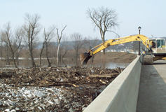
contractor using a backhoe loosens a jam of logs and other debris that
threatened damage to the Hwy 19 bridge at Henderson.
|
Mn/DOT representatives now help staff the State Emergency
Operations Center run by the Department of Public Safety’s Division of Emergency
Management, which coordinates flood-related activities statewide.
Bob Vasek, operations support engineer, Maintenance, and
liaison with the SEOC, said no major damage on the trunk highway system has
been caused by the flooding although several sections are or have been covered
by water.
Flooding has forced closing parts of several state highways
in several regions of the state, including Southeastern Minnesota, Northwestern
Minnesota, the Twin Cities area, the Minnesota River Valley and Isanti County
and Pine County in Northern Minnesota.
The sections of highway closed or covered by water changes
constantly with the flood conditions, he noted, making it difficult to predict
when flooded roads may open or have to be closed.
The state’s highways are threatened by further flooding from
the Mississippi, Minnesota and Red rivers as well as overland flooding stemming
from swollen creeks and tributaries.
The downtown St. Paul airport is threatened by rising waters
from the Mississippi River. Mn/DOT moved its aircraft to adjacent airports,
reports Dan McDowell, public affairs coordinator, Aeronautics.
 |
|
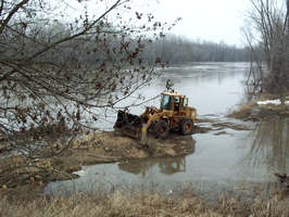
Peter Pink, transportation generalist at Metro's Jordan
Truck Station, supports the Mankato bridge crew's successful efforts to
break up a logjam in the Minnesota River at Belle Plaine by using a drag
line to pull the jam apart and free the trapped logs.
|
Mn/DOT crews have been working since last week to cope with
rising waters. In some areas, the almost-routine work entails erecting barricades
to close flooded highways, directing traffic and scraping mud when floodwaters
recede. In other instances, the work becomes tinged with drama.
Plowing debris
In Southeastern Minnesota, Rochester District crews from
Caledonia, Houston and LaCrescent were “plowing debris” as it floated over the
roadway on Hwy 16 near Hokah to keep the water-covered road open to traffic.
Crews from Stewartville, Preston, Spring Valley and Rushford responded to mud
slides and cleared tree limbs felled by high winds on Hwy 250 near Preston.
Hwy 250 also suffered shoulder washouts. High winds also toppled traffic signs
in the region, adding to the situation’s intensity.
Brian Jergenson, public affairs coordinator in Rochester,
reports that vandals either stole or tossed cones and barrels into the water
at Preston, creating a potentially dangerous situation for travelers.
Battling logjams
At Henderson and Belle Plaine, the bridge crew from the Mankato
District battled logjams that threatened to damage bridges over the Minnesota
River. The crew used a boat to attach winch lines to the logjams to break them
apart so they would flow down the river without causing damage to the bridges.
Ironically, the logs are the remnants of trees felled by
another disaster—the 1998 tornado that caused extensive damage in St. Peter,
according to Rebecca Arndt, public affairs coordinator, Mankato District.
Without the crew’s quick action, the logs could have caused
extensive scouring of the bridges’ piers, causing serious damage and requiring
extensive repair work. The crew placed riprap (loose stones) at the bridge piers
to prevent additional scouring from floating debris.
In the Twin Cities Metro area, rising waters from the Minnesota
River forced closing the Hwy 101 bridge between Shakopee and Hwy 212 and Hwy
41 between Hwy 212 and Hwy 169. Rising water on the St. Croix required closing
the Stillwater Lift Bridge at 8 p.m. on Tuesday.
Holding their breath
 |
|
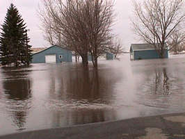
Buildings are submerged by flood waters near Hwy 27
southwest of Wheaton.
|
In west central Minnesota, crews from the Detroit Lakes/Morris
District have been working around the clock placing signs, cones and barrels
to close several sections of highway or to remove them as floodwaters recede.
Highway sections that remain closed include Hwy 27 from Browns Valley to Herman,
Hwy 55 between Barrett and Hoffman and Hwy 75, 12 miles north of Breckenridge.
At Breckenridge, crews from Breckenridge, Alexandria and
Fergus Falls are working intensely to resist the crest of the Red River moving
north. They have been hauling sand for sandbags, helping build dikes and monitoring
the condition of Hwy 75, which is closed north of the city.
“Right now,” said Dan Peterson, Alexandria maintenance supervisor,
“they’re just holding their breaths and waiting for the water to push through.”
The crew from the Breckenridge Truck Station, he added, has
evacuated the building after surrounding it with sandbags. Crew members are
working out of their trucks in close coordination with the emergency operations
center there until the flood crisis passes. Breckenridge crew members, he added,
have taken breaks only to prepare their own homes for flood conditions.
Peterson said water flooding overland from the east has receded,
but the possibility of one to two inches of rain falling Tuesday night and this
morning poses great concern in the battle against the floods.
In Isanti County north of the Twin Cities, floodwaters from
the Rum River forced closing Hwy 47 at the West Point Bridge two miles south
of Hwy 95. Traffic is detoured on county roads. Duluth District authorities
closed Hwy 123 between Askov and Standstone in Pine County due to high water
from Bear Creek.
The state’s northwestern corner also faces a flood threat.
In the Bemidji District,
Hwy 317 and Hwy 220 near Oslo are closed as ice jams on tributaries
cause overland flooding. Terry Sorenson, maintenance supervisor at Crookston,
said floodwaters in many areas are now receding, leaving behind some roads with
shoulder washouts.
“Right now we’re putting gravel on Hwy 200 and Hwy 9 where
we’ve had shoulder damage,” he said.
The Crookston area escaped major damage from flooding Sunday
when ice jams caused the level of the Red Lake River to rise about six feet
in just a few hours.
But the waters receded there and at other locations as well.
“Things are looking better,” he said.
Closing highways
 |
|
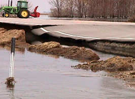
The Mustinka River damaged the road, shoulders and
edge drains on Hwy 27 east of Wheaton. Normally, the river is 500 feet
from the highway at this point.
|
In southwestern Minnesota, Mn/DOT crews from the Willmar
district closed several highway sections—including parts of Hwy 212 and Hwy
29 at Montevideo—to allow for dike building and pump stations. The floods of
1997 caused extensive damage in that city and in Granite Falls. Crews from the
district are making preparations to respond in case floodwaters threaten bridges
over the Minnesota River.
"We anticipate losing a river crossing today (Wednesday)
on Hwy 40 near Milan and Hwy 75 south of Madison to water over the road,"
reports Sandy East, public affairs coordinator in Willmar. She added district
officials are tracking other situations, including Hwy 212 between Montevideo
and Granite Falls, Hwy 67 at Granite Falls and portions of Hwy 212 at Glencoe
where flooding is imminent.
Vasek said the fast-changing flood situation is difficult
to predict, making it imperative for people to stay informed on the latest developments.
“Beyond what we’ve been doing locally, Mn/DOT hasn’t been
called on to assist with statewide resources yet,” he said.
Vasek and Kent Barnard, Office of Communications and Public
Relations, participate in a daily agency briefing at 1:30 p.m., followed by
a media briefing at 4 p.m.
To keep abreast of the changing flood situation, see Mn/DOT’s
road and weather conditions
Web site, the TripUSA alerts
site or the Division of
Emergency Management site.
By Craig Wilkins
District 4 photos by Myron Riley
District 7 photos by Rebecca Arndt
|


