|
|
|
|
 |
TABLE of CONTENTS
|
The end is near: Work nears completion on Hwy 52
Lafayette Bridge in St. Paul
|
By Kent Barnard
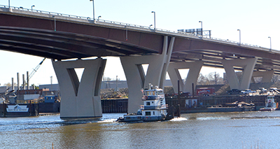
Two new bridges provide safer crossing of the Mississippi River east of downtown St. Paul. Photo by Rich Kemp |
Commissioner Charlie Zelle, St. Paul Mayor Chris Coleman and Melissa Donald, executive director of the East Side Area Business Association, attended the Nov. 10 ceremony celebrating the nearly completed Hwy 52 Lafayette Bridge in St. Paul.
The two new bridges will improve transportation by providing safer crossing of the Mississippi River east of downtown St. Paul and will save motorists time and money by reducing congestion while providing better connections from local roads. The project was awarded for $130.4 million and work on the new structures began in early 2011.
“This project is a great example of how we are modernizing the infrastructure as we repair and replace it,” said Zelle. “It provides greater service to the community and the traveling public in much the same space as the previous structure. It will provide an excellent return on the investment.”
The two new Hwy 52 bridges replace an aging structure that opened to traffic in 1968. The new structure features:
- Two through-lanes and an auxiliary lane in each direction for entering and exiting traffic
- An anti-icing system that will improve safety and apply chemicals onto the bridge deck before freezing conditions begin to prevent ice buildup
- A bicycle/pedestrian trail to the new northbound bridge to allow people to cross the river between Plato Boulevard and 7th Street
Two through-lanes, an auxiliary lane in each direction and a bicycle/pedestrian trail are part of the Hwy 52 Lafayette Bridge in St. Paul.
Photo by Rich Kemp |
The crossing also allows citizens to access the Bruce Vento Trail, Samuel Morgan Trail and Lowertown neighborhood, while providing a gateway to the Dayton’s Bluff neighborhood in east St. Paul.
“This is a great step in the right direction when it comes to investing in and improving St. Paul’s infrastructure,” said Mayor Coleman. “I look forward to continuing this work as we look to upgrade other crucial connections within the city, including the Kellogg Boulevard-Third Street Bridge.”
MnDOT also modified and realigned the Hwy 52 bridges crossing Interstate 94 and redecked the Hwy 52 bridges over Plato Boulevard and Eaton Street south of the Mississippi River. Work included repair and resurfacing of the Concord Street Bridge
Final completion of the project is underway and work is expected to be complete by the end of November. For more information on the bridge, check out the project website. |
|
|
|
|
|
TABLE of CONTENTS
|
MnPASS Express Lanes come to Twin Cities east metro area |
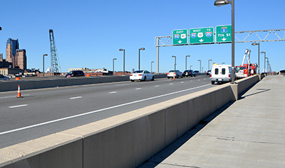
The new MnPASS lanes on I-35E in St. Paul will open Nov. 30. Photo by Rich Kemp |
The new MnPASS Express Lanes on Interstate 35E between Little Canada Road and Cayuga Street in St. Paul are nearing completion and are planned to open Nov. 30. MnDOT started enrolling new I-35E MnPASS customers on Nov. 17. Customers will be offered a free trial period on the I-35E MnPASS lanes from Nov. 30 to Jan. 4.
The I-35E lanes will look and operate similar to the MnPASS lanes on I-394 and I-35W. During peak drive times, vehicles with two or more passengers (HOV 2+), transit buses and motorcycles can use the lanes for free, while solo drivers can use the lanes for a fee if they have a MnPASS account and a MnPASS tag mounted on their windshield. During the trial period on I-35E, solo drivers with a MnPASS account and tag can use the lanes for free. Outside of peak drive times, the lanes are open to all motorists free of charge. The peak drive times for the MnPASS lanes on I-35E will be:
Monday-Friday
- Southbound MnPASS lane – 6-10 a.m.
- Northbound MnPASS lane – 3-7 p.m.
“The new MnPASS lanes coming to the east Metro are going to improve travel on I-35E for years to come,” said Brad Larsen, MnPASS policy and planning program director. “They’re going to reduce congestion for all motorists, provide a reliable congestion-free option during rush hour, and encourage greater transit use and carpooling.”
Some other new MnPASS features include the elimination of the current $1.50/month fee, and two new tag options for customers to choose from:
- Switchable tag
- $15 one-time purchase fee
- Can be switched between HOV 2+ (free) mode and MnPASS (fee) mode
- Can be transferred between vehicles
- Sticker tag
- Free
- Can’t be switched to HOV 2+ (free) mode – always on MnPASS (fee) mode
- Can’t be transferred between vehicles, but users can get as many free tags as they have vehicles

The MnPASS switchable tag can be switched between HOV 2+ (free) mode and MnPASS (fee) mode. Photo courtesy of MnPASS |
The new MnPASS lanes on I-35E, along with the other bridge, pavement and mobility improvements in the corridor will significantly improve travel on I-35E north of downtown St. Paul. Work on I-35E should be completed by the end of next year.
More information is available at www.mnpass.org or by contacting Larsen at 651-234-7024 or brad.larsen@state.mn.us, or Bobbie Dahlke, MnPASS Communications, 651-234-7088 or bobbie.dahlke@state.mn.us. |
|
|
|
|
|
TABLE of CONTENTS
|
"MnDOT Robot" developed to paint markings on roads |
|
In this video, University of Minnesota-Duluth Associate Professor Ryan Rosandich explains a robotic arm he developed to paint messages and markings on roadways. He calls the machine The MnDOT Robot. Video produced by Research Services and Library |
|
|
|
|
|
|
TABLE of CONTENTS
|
Two plans help set course for MnDOT vision, investment |
By Sue Roe
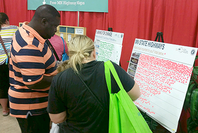
Fairgoers place stickers on poster boards that ask them what their transportation priorities are. The Office of Transportation System Management received comments from 4,500 people at the fair. Photo by David Gonzalez |
Two of MnDOT’s highest level plans are being updated in one joint process. The Statewide Multimodal Transportation Plan and the 20-year Minnesota State Highway Investment Plan help MnDOT plan and invest for the future of the state’s multimodal transportation system.
Based on the Minnesota GO vision, the SMTP is the visioning document that evaluates all types of transportation and what’s changing in terms of transportation trends and technologies, demographics, the economy and the environment. It provides a 20-year transportation policy framework. MnSHIP translates the SMTP objectives into a plan to invest MnDOT’s anticipated state road construction budget for such items as pavement, bridges, roadside infrastructure, bicycling and walking infrastructure on the state highway network.
Both plans are updated every four years and are required by state statutes. Before beginning the update process, planners in the Office of Transportation System Management evaluated how the 2012 SMTP and 2013 MnSHIP were implemented to date. Those assessments are available at www.minnesotago.org.
“MnDOT plans for all the ways people and goods move throughout Minnesota, individually for each mode and together as a multimodal system,” said Philip Schaffner, policy planning director in the Office of Transportation System Management. “Over the next 20 years, Minnesota is going to change in ways that affect our transportation system.”
MnDOT anticipates having approximately $20 billion for capital highway investments from 2018 to 2037.
“It might sound crazy, but $20 billion highway investment budget is tight,” said Kathleen Mayell, investment planning director in the Office of Transportation System Management. “Given our aging infrastructure, we need to make tough tradeoffs and establish priorities for the future. That’s why it’s important for us to get public and stakeholder input so we can prioritize the most important investments.”
This past summer, MnDOT began a public involvement effort to get stakeholder comments. The kickoff event was at the Minnesota State Fair, where MnDOT planners from the Office of Transportation System Management asked fairgoers what transportation trends and investment areas are most important to them. Results from the fair are available on the Minnesota GO website.
Other outreach techniques used include a balance of in-person and online tools so that engagement occurs statewide with many stakeholder groups, including underserved populations such as racially and ethnic minority groups, low-wage earners, non-English speakers, elderly and youth, and persons with disabilities. A key strategy is to go to where people already are rather than asking the public to come to MnDOT, so planners are going to community events, workplaces and existing groups throughout the state.
Schaffner said MnDOT employees can participate in the online surveys at www.minnesotago.org/. Internal staff meetings and presentations are also in the planning stages and any group wanting a presentation should contact Katie Caskey, Office of Transportation System Management.
Public and stakeholder outreach will continue into spring 2016 and draft plans will be released in summer 2016. Open houses, the public comment period and a public hearing will be held in fall 2016. Final adoption of both plans is scheduled in January 2017.
MnDOT has other plans that address the needs of each mode as well as the overarching needs of the whole transportation system. This “family of plans” includes bicycle, aviation, freight, rail, ports and waterways, pedestrians and transit.
“All plans are informed by the Minnesota GO vision and the SMTP,” Schaffner said. “There is some overlap between plans but ultimately they are woven together for the health of Minnesota’s people, environment and economy.” |
|
|
|
|
 |
TABLE of CONTENTS
|
Indigenous women are recognized during Native American Heritage Month event |
|
By Rich Kemp
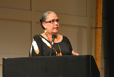
Sandy White Hawk, First Nations Orphan Association, spoke during the Native American Heritage Months Indigenous Women event Nov. 18. Photo by Rich Kemp |
The MnDOT Indigenous Employee Resource Group and the Department of Human Services American Indian Training Team coordinated Native American Heritage Month’s Indigenous Women event Nov. 18 at the Minnesota History Center.
The event was organized to celebrate the rich and diverse cultures, traditions and contributions of native people, especially Indigenous women. They are considered the backbone of the nations. However, much of their history of resilience and strength remains to be told.
“The purpose of the event was to recognize and remember who we are and always have been as Indigenous women,” said Waubun Smith, IERG member. “We honor the memory of the many remarkable Indigenous women who came before us.”
The program started with song and prayer by Indigenous women known as the Ogichida (warriors) singers.
Sue Mulvihill, MnDOT deputy commissioner and chief engineer, provided opening comments. Speakers included Nancy Bordeaux, Minneapolis American Indian Center; Sandy White Hawk, First Nations Orphan Association; Venassa Goodthunder, Dakota Wicohan Cultural Resource Center; and Dorene Day, Bois Forte Band.
“One way to help bring our relatives back who have been separated through adoption and foster care is through song and ceremony,” said White Hawk. “Remember that prayer is the strongest energy that all of us can express and receive.”
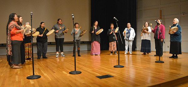
The Ogichida (warriors) singers performed during the Native American Heritage Months Indigenous Women event Nov. 18. Photo by Rich Kemp |
|
|
|
|
|
|
|
|
|
TABLE of CONTENTS
|
Visiting Central Office? Heres where to park. |
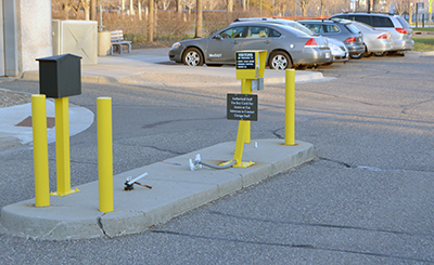
Visitors to the Transportation Building in St. Paul should pull into Lot G, adjacent to the south side of the building off Rice Street and use the intercom on the island to contact garage staff. Photo by Rich Kemp |
Parking can be difficult for MnDOT employees who do not work at the Central Office in St. Paul, but visit the Transportation Building occasionally for business.
To make it easier, MnDOT has secured 17 visitor parking spaces in Lot G, adjacent to the south side of the building, and implemented a voucher system to be used at meters located in state-owned parking lots and ramps. Included is Ramp F, which is connected to the west side of the Transportation Building.
“These visitor parking spots are specifically for MnDOT employees whose permanent work location is not the Central Office when they are visiting the Central Office for MnDOT business,” said Greg VanderVeer, Facilities Management Unit.
VanderVeer noted that when space allows, district engineers and non-CO office directors have the option to park in the garage beneath the Transportation Building. Their MnDOT identification badges are programmed to allow access to and from the facility during and after normal building hours.
All other MnDOT employees visiting the Central Office will receive a visitor hang tag for Lot G or a voucher for a parking meter, along with a map and instructions for parking at a state-owned meter.
Visitors using parking in Lot G, the garage or state-owned meters should note the following:
- No in and out privileges.
- No sharing of codes and tags with anyone else, including other employees.
- Employees must obtain a new code or hang tag upon each visit.
- Hang tags, keycards and parking meter receipts must be returned at the end of each visit.
- Employee will be responsible for the replacement cost of lost hang tags and keycards ($25 per lost Lot G hang tag; $10 per lost visitor badge).
Non-MnDOT visitors and MnDOT employees whose permanent work location is the Central Office are not allowed to park in the Lot G visitor spots, in the Central Office garage or use the parking meter vouchers without advance approval from the MnDOT commissioner, deputy commissioner, chief of staff, assistant commissioner or Office of Administration director.
Employees should refer their non-MnDOT visitors to the Department of Administration’s Public Parking website for Capitol Complex visitor parking information.
For more information, visit MnDOT’s parking website or contact VanderVeer at greg.vanderveer@state.mn.us or 651-366-3047. |
|
|
|
|
|
|
|
 |
TABLE of CONTENTS
|
Metro Green Line wins economic impact award |
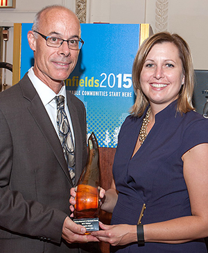
Jim DeLuca, MnDOT hydrogeologist, and Jackie Dylla, Braun Intertec, received the Renewal Award in the Economic Impact category at the annual National Brownfields Conference Sept. 3 for the Metro Green Line project. Photo courtesy of the Brownfields Awards |
The Central Corridor Light Rail Transit/Metro Green Line won the Renewal Award in the Economic Impact category at the annual National Brownfields Conference Sept. 3. Stakeholders accepting the award included MnDOT, the Metropolitan Council and Braun Intertec, the project environmental consultant.
The Renewal Awards are presented at the annual conference, hosted by the International City/County Management Association and the U.S. Environmental Protection Agency. The National Brownfields conference showcases prominent redevelopment projects from all over the country, and includes seminars, workshops, poster sessions and lectures. Brownfields are defined by the EPA as real property, the expansion, redevelopment, or reuse of which may be complicated by the presence or potential presence of a hazardous substance, pollutant or contaminant. In other words, Brownfields are environmentally stressed properties that are underused because of an environmental stigma.
“MnDOT played a critical role to ensure that contaminated soil and regulated materials were managed properly on these transit projects,” said Brian Kamnikar, principal engineer.
Along with historical transit uses, the Central Corridor was home to a variety of land uses with recognized environmental concerns such as grain elevators, machine shops, automobile repair, tire vulcanizing, gas holders, chemical laboratories, foundries, paint and varnish manufacturers, steel and iron factories, printers, gasoline filling stations, bulk petroleum facilities, electrical substations, battery shops, railroad yards and dry cleaners.
Due to the historical use, the transit corridor had underlying contamination, making it a massive underused Brownfields area. According to the Minnesota Pollution Control Agency, 7 percent of Minnesota's contaminated sites are located within the corridor.
In June 2014, the METRO Green Line opened to passenger service. Daily ridership is projected to reach 40,000 passengers by 2030. It is estimated that approximately $2.5 billion in redevelopment of the corridor is planned or underway as a direct result of the METRO Green Line project. Successful cleanup of the METRO Green Line not only created a new light rail transit line, but also created the opportunity to strengthen the regional economy and make the adjacent neighborhoods a safer environment for living, working and playing.
In total, the project disposed of approximately 192,000 tons of contaminated soils and reused approximately 20,000 tons of low-impact contaminated soils on the project at inaccessible depths. In addition, more than 150,000 linear feet of asbestos-containing lighting conduit was removed and replaced, 24,000 tons of asbestos containing waste material was removed over an entire downtown St. Paul city block, and other hazardous/regulated materials including ash, coal tar, and orphaned underground storage tanks were removed. Braun Intertec provided the environmental consulting services to manage this cleanup, with MnDOT Office of Environmental Stewardship staff overseeing the effort.
“Karlene French and Jim DeLuca, hydrogeologists with the Office of Environmental Stewardship, were instrumental with overall management of these environmental issues,” said Kamnikar. “Mark Vogel and Jackie Klein, regulated material specialists with OES, also provided expertise on handling of asbestos containing materials on the projects.” |
|
|
|
|
 |
TABLE of CONTENTS
|
Creating a more walkable Minnesota |
By Jasna Hadzic,
Office of Transits pedestrian and bicycle section
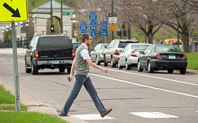
A pedestrian steps into a crosswalk on John Ireland Boulevard in St. Paul. MnDOT and the Minnesota Department of Health are working on Minnesotas first Statewide Pedestrian Plan to ensure that walking in Minnesota will be safe, convenient and desirable for all. Photo by David Gonzalez |
It’s an early and sunny Monday morning as I make my way half tiredly down the sidewalk and set my foot in the crosswalk on Rice Street, outside MnDOT’s Central Office. I am abruptly stirred out of my sleepy state as I notice cars whizzing by realizing that not only are they not going to stop for me, but they are not even going to consider slowing down. I take a step back and walk over to the signal push button. As the walk sign lights up, I swiftly yet cautiously dash across the busy five-lane road.
Just a mere 24 hours earlier I was reveling in the streets of Washington, D.C., and as quickly as those cars were passing by me on Rice Street, I realized I was no longer in “walker’s paradise.” Ironically, I had just spent the week in D.C. for the biggest walking event in the nation, the National Walking Summit, where experts and walker advocates alike gathered to celebrate the emergence of the walking movement and the U.S. Surgeon General’s Call to Action on walking and walkable communities.
My excitement from the great week and fresh enthusiasm from Washington, D.C., quickly came to a halt as I heard of what seems to be never ending and deeply saddening news of tragic pedestrian fatalities that had occurred over the weekend. One of them was a little boy.
It is for these reasons that MnDOT and the Minnesota Department of Health are stepping up and paving the way for Minnesota’s first ever Statewide Pedestrian Plan. As best put in the words of Dr. Robert D. Bullard, father of environmental justice, during his talk at the Walking Summit, “walking is a civic right” and this plan will begin to ensure that walking in Minnesota will be safe, convenient and desirable for all.
Many cities, states, countries have already figured it out – walkable places increase quality of life, health outcomes, economic vitality and many other benefits we hear of all the time. The U.S. Surgeon General’s acknowledgement of the work Minnesota is undertaking during his highly awaited speech at the Summit ignites and provides support and encouragement that there is no better time than now to step up and focus on improving the lives of Minnesota residents by creating walkable communities. It is not to discredit other modes, but to co-exist and provide equitable choices for all without undermining the sole purpose of what we are all made to do – walk.
Even more so, with the last few months of community engagement for the pedestrian plan, more than 3,000 voices of Minnesota residents from different corners of the state have been heard loud and clear – people want to be able to walk to the park, grocery store, school and transit. Even more so, it is good sidewalks, snow and ice removal, presence of other people and quiet streets/low traffic that make walking safe, convenient and desirable in various communities around the state.
The next step for MnDOT and MDH is to write the recommendations for policies, projects and programs at the state, regional and local levels. But the most crucial work is yet to come – the implementation of the plan and support from other agencies, advocates, developers, policy makers and all those who have a stake at advancing the quality of life of all Minnesotans. It is only then that we will start to see a shift and an end to these tragic headlines and support Minnesota’s Vision of maximizing the health of the people, the environment and the economy.
For more information about the Statewide Pedestrian System Plan or to take the survey, visit: www.minnesotawalks.org |
|
|
| |
|