By Sue Roe
Editor's note: This is the first of a two-part series about the flood of 1965 and MnDOT’s flood mitigation efforts.

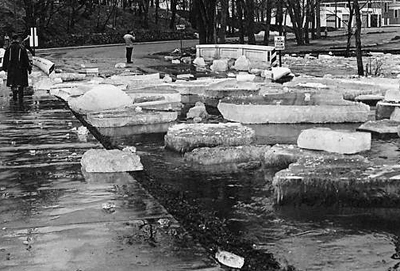
Huge chunks of ice from the Mississippi River cover Riverside Avenue in Sartell after a massive ice jam broke apart in April 1965. Photo courtesy of the Stearns History Museum |
April marks the 50th anniversary of what some people still refer to as the flood of the century in Minnesota. The 1965 flooding caused destruction in five states and only the northeastern and far northern parts of Minnesota escaped nature’s force that year.
Thirteen people died in Minnesota and damage to property ran into the millions of dollars.
A record cold and snowy spring, followed by rapid thawing and rainfall caused the widespread flooding along many of the state’s river basins.
In St. Cloud, 51.7 inches of snow fell in March and 35 inches were still on the ground on March 29. Two weeks later, only a trace of snow remained. At the state’s official recording station at the Minneapolis-St Paul airport, precipitation was recorded on 16 of 30 days in March.
“Many of the streams, which were covered by snow and ice in March, were raging torrents in full flood in April,” according to 1970 report issued by the U.S. Department of Interior.
The Minnesota River crested at 17 feet above flood stage on April 15 at Savage. A day later, the Mississippi River crested at 12 feet above flood stage at St. Paul, where 800 people were evacuated from low lying areas and flooding was a mile wide. The flooding continued its damaging path downstream. The Mississippi remained at flood stage for nearly a month.
MnDOT maintenance crews worked around the clock to keep highways open to traffic, close them when they became unsafe, keep bridges and culverts clear of ice and debris and fill in eroded areas. Crews also operated snowplows to push chunks of ice from highways and partnered with other groups to fight off the flooding.
The November 1965 Minnesota Highways, MnDOT’s employee magazine at the time, reported maintenance crews worked 13 to 16 hours a day, seven days a week for flood cleanup.
“The St. Paul airport had seven feet of water on its runway,” remembers Dick Lambert, retired MnDOT Ports and Waterways director.

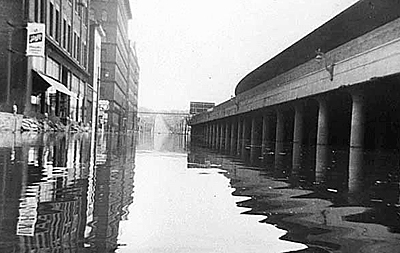
This is what Kellogg Blvd. looked like during the 1965 flooding. Photo courtesy of the Minnesota Historical Society |
George Thibault worked in the right of way office in 1965. “I just moved to Eagan and there weren’t many places to cross the Mississippi River into St. Paul. Interstate 35W in Burnsville was closed and I-35E wasn’t built until the 1980s. Shepard Road through downtown St. Paul had six to eight feet of water.”
On April 10, 1965, the Minnesota River at Mankato crested at the second-highest level ever reached, just shy of the flood of 1993. More than 60 inches of snow fell that winter and spring. At Granite Falls, near the start of the Minnesota River, officials used dynamite to blow out ice jams. That sent the flow of water toward Mankato.
Petra DeWall, waterways engineer in the Bridge Office, remembers reading about the Mankato area flooding when researching bridges for a scour study.
“The Minnesota River almost took out the old bridge on Hwy 169 north of LeSueur. At the time, flood plain pier foundations were set higher than channel piers to save money,” she said. “The flooding caused the river to change course, moving the main channel into the flood plain. Several of the piers were subjected to scour, exposing the pilings. MnDOT hired a company to design scour countermeasures to make sure the river wouldn’t shift again.”
Bridges, local roads and culverts were battered statewide. Although few bridges actually washed out or were heavily damaged, the surging flood waters and ice jams wrecked bridge pilings, piers, decks and railings.
“One bridge had to be dynamited and bulldozed because ice jams damaged the structure. There were areas where channels were cut to a depth of more than 20 feet below the highway surface and up to 200 feet long,” according to the May 1965 Minnesota Highways.
No major segments of trunk highways were wrecked or washed out. Some of the damage was because narrow snowplowing during the harsh winter left high snowbanks along the shoulders. When the snow melted, the shoulders eroded. Damage to state highways was costly not because of the heavy destruction in limited areas, but because lesser damage was so widespread.
John Swanberg, chief engineer of the then Minnesota Highway Department, wrote, “The trunk highways’ major survival of so much fast moving water for so long a period is convincing evidence that the Highway Department over the years has built well against the destructive forces of nature, in choice of location and in sturdiness of design and construction. It is evidence, also, that roadways and bridges were well maintained over the years against deterioration.”
See YouTube videos of the Mankato area flooding at https://www.youtube.com/watch?v=o28q8DfMJYE or https://www.youtube.com/watch?v=unD0m976XF4
Next issue: We’ll take a look at what MnDOT does today to protect infrastructure and keep people safe from flooding.
|


