 |
|

|
 |
TABLE of CONTENTS
 |
New water safety training prepares bridge crews for emergencies |
By Bob Filipczak
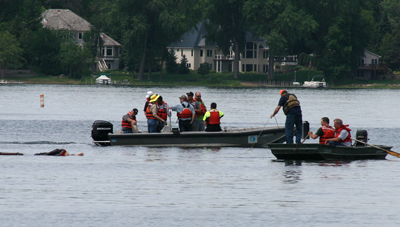
Trainees in the water safety training program, retrieve a dummy on Turtle Lake in Shoreview in June. Photo by Julie Libonate |
In the land of 10,000 lakes, it’s no surprise that MnDOT workers spend more time on the water than transportation professionals in other states…especially bridge workers. That’s why a new water safety training program, with an emphasis on how to respond to water emergencies, is so important.
The pilot for this new training took place in June, with classroom time in the morning and then an afternoon session on Turtle Lake in Shoreview. The hands-on training, explained Keith Juliar, MnDOT’s acting safety director, was reported to be the most valuable.
The first challenge was the buoy toss, where trainees practiced tossing safety buoys at targets. This was not as easy as it might seem, according to attendee Julie Libonate, Metro District safety supervisor. She said the buoys were heavier than they looked and participants had to throw them more like a Frisbee to get them to sail in the right direction.
Next was dummy retrieval. John Lindstrom, water safety trainer from Hennepin Technical College, brought along his own victim—a weighted dummy the trainees threw in the water and then retrieved. This was the maiden voyage for the training dummy, too, which weighed approximately the same as a human to more accurately simulate the difficulties of pulling someone into a boat after they’ve hit the water. In the future, Juliar said he wants to practice with real humans in the water to expose trainees to an even more realistic water emergency simulation. This will allow them to communicate with the victim while they are pulled to safety.
“This initial training effort was a good first step into incorporating water safety training to all of MnDOT’s bridge maintenance crews,” said Juliar.
The first session included 50 employees from bridge offices around the state. With a bridge office in every district and five of them in the Metro District, more classes will be needed in the future.
Juliar will work with Hennepin Technical College to tailor the course to MnDOT’s needs over the next year. Bridge maintenance workers interact with rivers and lakes in unique ways… examining piers for scour, clearing debris from around piers, hanging above rivers during inspections, etc. Those unique needs will be incorporated into future water safety courses.
It’s also important to stress how much emergency prevention was built into this course.
“Because the crews are working out on the rivers in early spring and late fall, there was an emphasis on what to do to prevent hypothermia and how to treat it,” said participant Nicole Bartelt, a principal engineer with the bridge hydraulics unit.
Is it worth it? It’s difficult to know how many emergencies will be avoided due to the training, but according to the American Society of Safety Engineers, $1 invested in safety training saves an organization at least $3--with the actual cost of a workplace accident coming in between $45,000 and $75,000. |
 |
|

|
 |
TABLE of CONTENTS
 |
Hwy 10 interchange breaks standard design rules to minimize impacts, costs |
By JP Gillach, District 3 public affairs coordinator

Bridge beams for the new Hwy 10 interchange in Rice were delivered one-by-one on semi-trailers and placed using two cranes July 1. Photo by Dan Gilder |
In the fall, a new interchange will open in the small town of Rice in MnDOT's District 3. The interchange replaces an at-grade signalized intersection and will improve safety and mobility.
While Rice may be small, the traffic demands are high. Seasonal recreational traffic on Hwy 10 can hit fairly extreme peaks on weekends and holidays. Local retail stores and manufacturers generate traffic essential to the local economy, and commuters to the St. Cloud area mix with the hum of interregional traffic each weekday.
The combination of traffic demand, local economic concerns and a limited existing right of way led to a unique interchange design.
The design features a non-standard exit ramp from westbound Hwy 10 to County Road 2. The ramp connects to the existing County Road 2, using the original road and alignment, which allows County Road 2 to remain intact and serve double duty as a collector/distributor road. The design also takes advantage of an existing local road to connect the ramp from Rice to westbound Hwy 10. The strategy of using the existing roads allowed staging that maintains access to local businesses while the interchange’s bridges are being built. The strategy also reduced the need to acquire expensive right of way to accommodate a standard diamond interchange ramp. Connections to eastbound Hwy 10 use standard ramp designs.
To keep Hwy 10 flowing adequately during construction, four temporary lanes will carry Hwy 10 traffic until the new, permanent lanes open.
Construction of the interchange began in fall 2013 and has gone as one would expect, with its usual fair share of interesting challenges.
After a change in staging plans put the project well ahead of schedule at the end of 2013, 2014’s spring weather put the project slightly behind schedule. Crews continue to make up that time, and the project will still be completed this year.
In one of those Twilight Zone moments, the new bridge’s beams were hit by a farm implement soon after they were installed.
“We set the beams, and within eight hours somebody hit those beams with a high load,” said Joe Cameron, project supervisor. “It didn’t damage the bridge beams. However, it was a farm disc with the marker wheels left up, and the hard part is explaining to people how you get tire tracks on the bottom of a bridge beam.”
The bridge itself also uses no piling for the foundation. Instead, it uses an unusual spread footing made from geotextile cloth filled with sand.
“It looks like a big bean bag,” said Cameron. “We have been monitoring the abutments for movement, and they haven’t moved one bit during building of the abutments, setting beams and pouring decks.”
Local constituents also appear to be happy with the project, and project leaders have received very few negative comments from businesses.
For more information on the project, visit the project website at www.dot.state.mn.us/d3/hwy10rice/. |
 |
|

|
 |
TABLE of CONTENTS
 |
511 mobile app receives nearly 1.2 million views in its first year |
|
By Sue Roe
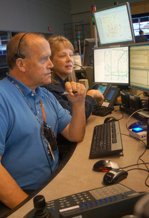
Donnie Zenanko, traffic operations dispatch, and Kelly Braunig, 511 coordinator, work in the Regional Transportation Management Center. Minnesota was one of the first states in the country to implement 511. Photo by John McClellan |
Travelers throughout the state relied on MnDOT’s 511 traveler information system’s mobile app to the tune of nearly 1.2 million views in the first year.
The free mobile app, launched in July 2013, gives up-to-date information on weather-related road conditions, maintenance and construction projects and crashes. Travelers can also use the www.511mn.org website or call 511 to access the information.
“We’re pleased the mobile app is getting so much use. We were the first state in a 12-state consortium to launch it and we think it’s going to continue to grow,” said Kelly Braunig, 511 coordinator.
She said 118,000 people used the app in its first year to help them plan their routes.
“Whether it is snowing or flooding, people want to know if any closures or bad roads will affect their travels,” she said.
Usage correlates with weather events and construction projects. On average, more than 2,000 people use the app each day. Braunig said the peak usage day was Feb. 21, 2014 when 34,000 people used the app. Up to 17 inches of snow fell in some parts of the state that day.
A web page for truckers launched at the same time as the mobile app. Truckers can find information, such as weight and width restrictions, and where roundabouts, weigh stations and construction projects are located. Braunig said there were 169,000 hits in the first year. The peak day was also Feb. 21 with 19,000 hits.
“The web page is an important resource for truckers. If they get caught in a detour, they’ll lose time delivering their cargo,” she said. The Web page is located at www.511mn.org.
Braunig said future enhancements are planned to the 511 system that will continue to make it a valuable resource for drivers.
“We’re excited to see where the technology is going to take us. The technology has grown so much and there is continued demand for it so we have to continue to improve.”
The app can be downloaded by going to www.511mn.org. |
 |
|

|
 |
TABLE of CONTENTS
 |
Teams report quarterly progress on enhancing MnDOTís financial effectiveness |
By Mary McFarland Brooks
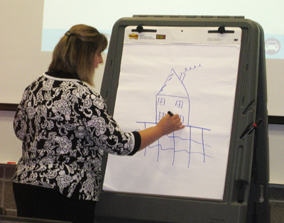
Tracy Hatch, deputy commissioner, chief financial officer and chief operating officer, uses a sketch while discussing MnDOTís Enhancing Financial Effectiveness program in Bemidji July 29. Photo by Reid Baumann |
Members of the four teams spearheading MnDOT’s Enhancing Financial Effectiveness effort shared their achievements and next steps with senior management at a daylong meeting July 14.
Those teams (or “Battles,” in the Four Disciplines of Execution lingo) focus on Financial Management, Asset Management, Project Management, and Information and Outreach.
One big change since the last quarterly report in April is the refocusing of the Financial Management strategic area, which is now split into two special project teams: Products & Services and Efficiencies.
“This allows the teams to compare costs of products and services to the approved budget, and determine efficient use of resources both internally and externally,” said Dan DuHamel, Financial Management team lead. “It also helps agency managers to make effective decisions and manage risk to meet performance objectives.”
Also driving the change is 2014 legislation that requires MnDOT to report information on efficiencies implemented in FY 2015 in the planning and project management and delivery areas. According to the statute, these efficiencies must save, at minimum, the equivalent of 5 percent of the total state road construction budget for FY 2015.
“Since early June, the Efficiencies Team has been analyzing and assessing all facets of the organization’s transportation delivery, to be able to evaluate the total efficiency savings and the daily tradeoffs the agency makes,” said Tracy Hatch, deputy commissioner/chief financial officer/chief operating officer, in an Aug. 5 email to employees.
“We know the efficiencies conversation will be a large part of the next legislative session. This ground work will be vital to gaining strong support for transportation investments,” she said.
Visit the Financial Management Battle web page for more information, including materials from the July 14 presentation.
Asset Management
The Asset Management team’s focus is identifying lifecycle costs (i.e., construction, maintenance, rehabilitation and replacement) for pavement, bridge, hydraulic infrastructure, tower lighting and overhead sign structures to improve overall cost-effectiveness. The goal is to achieve this by October 2015.
Processes evaluating the quality and accuracy of recorded data (primarily timesheet entries) were put in place, according to Dave Solsrud, project manager. The next step is to translate that data into mathematical models to predict current and future cost of maintenance according to the asset’s condition. Capital and operational decisions are merged with lowest lifecycle costs, for maximum financial effectiveness.
“Care in timesheet recording and coding has always been important to the department. By applying the results directly to the asset management effort, it’s an opportunity for every employee to influence our financial effectiveness and the agency’s future,” Solsrud said.
Project Management
The Project Management team is focusing on schedule management, specifically, a more balanced letting (awarding of contract) schedule to:
- Avoid bids from contractors whose crews may be overbooked
- Maximize cost savings
- Balance work load
Along with maximizing the letting schedule, the Project Management team is working to ensure that projects are scoped properly, which means project planning that determines and documents a list of specific project goals, deliverables, tasks and deadlines. A proper scope results in maintaining budget and schedule goals. The team is reaching out to districts to help deliver road construction project effectively, which is dependent on accurately scoping projects.
“The districts and functional groups are really starting to embrace the PM Battle. For example, negative float dropped about 10 percent since January,” said Jay Hietpas, Project Management team member.
The team is also working on Resource Concurrence to support the schedule goals. Anticipating intense work periods and planning ahead to obligate available resources to address these increased workloads will translate into maintaining project schedule and budget. The process will allow consensus by the end of October 2015 on delivery dates and resources needed to deliver projects for FY 2016.
Information and Outreach
The Information and Outreach team’s purpose is to communicate the progress and actions taken by MnDOT to answer key customer/stakeholder questions and demonstrate the efficient and effective use of public funds. During the last quarter, there has been a significant increase in agency news releases incorporating Enhancing Financial Effectiveness messages, with Greater Minnesota public affairs coordinators contributing 89 news releases and the Metro District 35 news releases.
For example, a news release from Jeremiah Moerke, District 4 public affairs coordinator, included this about a project installing cable median barriers:
“Cable median barrier prevents vehicles from crossing medians and hitting oncoming traffic. The relatively low cost of the cable barriers compared to other barrier systems allows the Minnesota Department of Transportation to cover more miles of the state highway system for the same amount of money. Since 2004, crews have installed more than 390 miles of the barrier in Minnesota. It’s estimated the barriers have saved 80 lives.”
“Including examples of innovation and efficiency in communications in local, regional and statewide news releases is a high-priority lead measure for the I&O team. We expect to reach, and likely exceed, our goal of 150-plus stories by the end of October, thanks to the work of District PACs and Metro and CO Communications,” said Jeanne Aamodt, project manager.
Keep up to date on EFE progress by going to http://ihub.dot.state.mn.us/efe/index.html. |
 |
|

|
 |
TABLE of CONTENTS
 |
Donated vacation hours sought for Adelberto Batica, George Costilla |
Adelberto Batica has been diagnosed with acute respiratory failure and is eligible for the state vacation donation program. Photo by Nick Carpenter |
Two Office of Civil Rights employees are now eligible for the state vacation donation program, which allows employees to donate up to 40 hours of vacation per fiscal year for approved recipients who have exhausted their sick and vacation leave due to life-threatening injury or illness.
Adelberto Batica, a 24 year MnDOT employee, has been diagnosed with acute respiratory failure from acute coronary disease and was recently admitted to the hospital. He was intubated for life support and later he had multiple coronary artery stent insertions. He will continue to need close monitoring for this life-threatening condition.
Due to his ongoing need for medical care, Batica has exhausted all of his vacation and sick leave.
George Costilla is also eligible for the state vacation donation program.
Costilla, employed at MnDOT since 2012, has been diagnosed with coronary artery disease. He was also diagnosed with systolic heart failure and an ischemic cardiomyopathy; he will have to undergo cardiac rehabilitation.
As a result of the extensive medical procedures and ongoing need for medical care, Costilla has exhausted all his vacation and sick leave.
To donate vacation leave:
- Go to Employee Self Service Website, click on “Other Payroll,” then “Leave Donations.”
- Click on “Input Your Leave Donations,” then select the magnifying glass next to “Reserve Bank” and choose recipient name
- Enter the number of hours you wish to donate
- Click on the yellow “Save” box
Donation forms are also available from your Payroll or Human Resources office or at www.mmb.state.mn.us/doc/vacation/pe665.pdf. |
 |
|

|
|

|
 |
TABLE of CONTENTS
 |
Employees invited to view St. Croix Crossing bridge construction up close |
By Jessica Wiens

The St. Croix Crossing project team is narrating nine public paddleboat tours hosted by the St. Croix Boat & Packet company throughout the 2014 construction season. All of the remaining four tours are full, but additional public tours will occur in 2015 and 2016. Photo by Jessica Wiens |
MnDOT employees, WisDOT employees and their families are invited to visit the St. Croix Crossing bridge construction site near Stillwater on a paddleboat tour during after work hours.
“We’ve had several offices, groups and individuals ask to visit the site,” said Jon Chiglo, St. Croix Crossing project director. “Since we can’t accommodate all of these requests, this is our solution to provide the opportunity for all interested employees who want to see the progress.”
Event dates are Monday, Aug. 11, and Wednesday, Sept. 17, from 5-6:30 p.m.
Employees who attend are doing so on their personal time and using personal funds for their boat ticket and mileage to Stillwater.
Online registration and payment is available through the St. Croix Boat & Packet at this link. Cost for a boat ticket is $8 for adults, $5 for children age 4-12 and free for children age 3 and younger.
As of Tuesday, Aug. 5, about 170 people are registered for the Aug. 11 tour and about 100 people are registered for the Sept. 17 tour. The boat’s capacity is up to 600 people.
The paddleboat leaves from St. Croix Boat & Packet at 5 p.m., so attendees should plan to arrive a few minutes early. The boat dock address is 525 S. Main St., Stillwater.
Free parking is available adjacent to the boarding area. Follow the ‘Boat Parking’ sign.
|
 |
|

|
 |
TABLE of CONTENTS
 |
Updates are made to visitor parking process
|
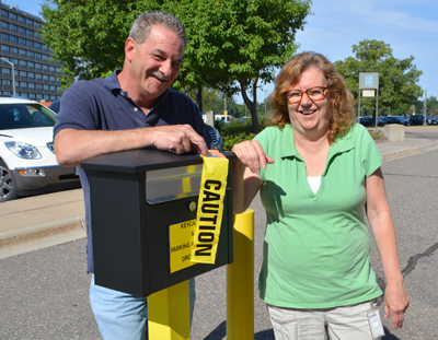
The CO garage staff, Tom Tufenk and Nancy Guillette, stand near the drop box that is now located on the island located between Lot G and garage entrance on the south end of the transportation building. Photo by Rich Kemp |
As a service to district and other employees, MnDOT has parking spaces for visitors to the Central Office. The parking spaces are for MnDOT employees who need to attend meetings and training in the building.
Employees are asked to drive to the garage entrance on Rice Street to sign in, get a temporary parking permit and receive directions to where they can park. The entrance is at the south end of the Transportation Building. Employees should enter the driveway between the building and Lot G and press the intercom located on the island. A garage employee will open the door so visitors can drive into the garage.
Visitors will receive a hang tag for their car to park in the visitor lot. They will also receive a visitor’s badge that must remain visible while they are in the Transportation Building.
Parking is available on a first-come, first-serve basis.
“All the hang tags are sent out just about every day,” said Tom Tufenk, garage operations.
For the convenience of visitors, the drop box for return of the hang tag and badge has moved to the island in between Lot G and garage entrance. When leaving the building for the day, visitors can leave the hang tag and badge in the drop box.
“It is more convenient for our visitors,” said Tufenk. “Before, they had to park and get out of the car to find the drop box in the building.”
To help with the process, employees can email a list of names to the Information Desk in advance, at Information Desk, CO whenever several employee visitors are expected for a meeting or training,
|
 |
|

|
 |
TABLE of CONTENTS
 |
MnDOT crew competes in Dragon Boat race |

As part of the Dragon Festival to celebrate the diverse Asian Pacific cultures, a team from MnDOT participated in the Dragon Boat race July 12 in St. Paul. The team, led by Eric Davis, chief of staff, and Sophia Yang, executive assistant to the chief financial officer, finished eighth in the competition. Photo by David Gonzalez |
|
 |
|

|
 |
TABLE of CONTENTS
 |
Metro District earns regional AASHTO award for I-694 North Central Project |
By R. Kent Barnard, Metro District Public Affairs
The project team was able to redesign the I-694/Hwy 10 interchange plan to achieve savings in materials and labor. The project received an award from the American Association of State Highway and Transportation Officials July 29. Photo courtesy of the Metro District |
After the dust settled from construction on Interstate 694 in Arden Hills last November and the votes were tallied this spring, Metro District’s I-694 North Central Projects was honored July 29 with an award from the American Association of State Highway and Transportation Officials. The regional award in the Under Budget category recognized the project for delivering value for transportation dollars.
“This is a great example of MnDOT delivering efficient work and transportation solutions that meet community needs,” said Metro District Engineer Scott McBride.
The project, which rebuilt the I-694/Hwy 10 interchange at Snelling Avenue (Hwy 51) and Hamline Avenue in Arden Hills, began in September 2011. It is one of nine projects planned for the I-694 North Central area, which also includes Shoreview, New Brighton and Mounds View.
The original design carried a price tag of $143 million and would have rebuilt the highway corridor eight lanes wide along with other major improvements. However, funding deficiencies required an extensive review of the project to maximize benefits at a reduced cost. The project team, led by Mark Lindeberg, North Area engineer, made an in-depth examination of the project and redesigned the project to achieve savings in materials and labor. Their changes included reducing the number of lanes from eight to four and eliminating two bridges.
With $25 million in bridge funds available to replace nine aging 1960s-era bridges in the corridor, Metro District secured additional money through a program to make capacity improvements to cover the revised project cost of $42.6 million.
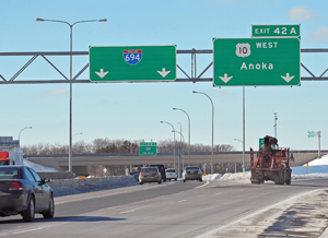
The Interstate 694/Hwy 10 interchange project in Arden Hills is one of nine projects planned for the I-694 North Central area, which also includes Shoreview, New Brighton and Mounds View. Photo by David Gonzalez |
In addition to the challenge of whittling down the scope of the work, project staff faced the daunting challenge of obtaining municipal consent from the city of Arden Hills, according to Lindeberg. Municipal consent was needed to remove access from westbound I-694 to Hamline Avenue and from Hamline Avenue to eastbound I-694. In order to handle the traffic displaced by those changes, MnDOT widened the Lexington Avenue Bridge crossing the interstate to better accommodate bicycle and pedestrian traffic and to create dual left-turn lanes to the interstate from Lexington Avenue at each end of the bridge.
The new plan was able to accomplish 85 percent of the larger project by rebuilding the bridges, reconfiguring the roadways and replacing aging pavement. The final product has improved traffic flow and reduced congestion along with improving safety, enhancing transit and spurring economic development, most notably the new 100-acre mixed-use New Brighton Exchange. The improvements have also helped with Ramsey County’s plans to clean up the 427-acre Twin Cities Army Ammunition Plant on the north end of Arden Hills to allow for mixed home and business development set to begin in 2016.
The project competed against 73 construction projects from 36 AASHTO member states and the District of Columbia. The three categories were “Under Budget,” “Best Use of Innovation,” and a new category, “Quality of Life/Community Development.” More information about the competition is available at AmericasTransportationAwards.org. |
 |
|

|
 |
TABLE of CONTENTS
 |
Maintenance crews mow roadsides for safety, environmental reasons |
By Sue Roe
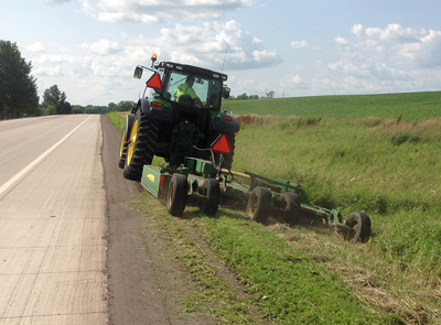
Roger Wersal, maintenance worker out of the District 8 Hutchinson Truck Station, mows a strip of roadside near Hutchinson. Mowing is usually limited to shoulders and medians. Prescribed burns and biological controls are also used to control weeds. Photo by Jerry Eggert |
Mowing the state highway rights of way is in full swing after the wet spring delayed MnDOT maintenance workers from starting the job earlier. MnDOT crews mow approximately 45,000 acres of land annually.
MnDOT, like other landowners in the state, is required to control plants on the Department of Agriculture’s restricted noxious weed list. Mowing is one way MnDOT controls them. Many of the plants seen along roadsides display vibrant colors when in bloom, but to the trained eyes of MnDOT’s roadside vegetation crews, they are invasive and a threat to native plants, animals and ecosystems.
“We want a diverse plant population on our roadsides because it’s healthier to have different kinds of plants and grasses,” said Tina Markeson, roadside vegetation supervisor. “When invasive species take over, it causes issues in the long run.”
Markeson cited purple loosestrife as an example of an invasive plant that competes with native species. Purple loosestrife can form dense stands that replace native plants needed by wildlife for food and habitat.
Mowing is usually limited to shoulders and medians to:
- Maintain sight distances for crossing and merging traffic
- Allow motorists to see approaching wildlife
- Aid in the identification of erosion issues
- Allow people to exit the vehicle if needed
State law restricts mowing the entire right of way until after July 31 to protect ground-nesting birds.
Timing of the mowing is important to prevent seed formation and so plants are not moved down the road in mowing equipment.
“We aim to mow when plants are in their bud stage, so we’re not spreading the seeds and making the problem worse,” Markeson said. “Knowing the weed and the timing of its development saves money so the right method or combination of methods is used at the right time.”
Some of MnDOT’s mowers have automated vehicle location systems to help maintenance crews mow around noxious weed patches. Operators use an on-screen map to mark new areas of noxious weeds and go back at the right time to mow or spray. The technology also tracks the use of herbicides, when used, so operators can better track where areas are sprayed. The technology is anticipated to reduce herbicide usage by 50 percent.
MnDOT also uses prescribed burns and biological controls to control weeds.
“MnDOT’s goal is to provide a roadside environment that is ecologically appropriate and self-sustaining and maintains scenic qualities, while ensuring traveler safety,” Markeson said.
For more information, go to MnDOT’s roadside vegetation management program website, www.mndot.gov/roadsides/vegetation/. |
 |
|

|
 |
TABLE of CONTENTS
 |
Online bicycle route-finding tool expands statewide |
By Sue Roe
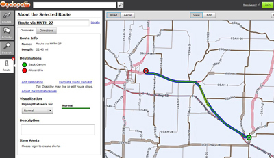
The Cyclopath program helps bicyclists plan routes throughout the state. |
Bicyclists planning routes throughout the state can now use an editable, interactive online map called Cyclopath to help customize their trips.
Cyclopath is designed to find bicycle routes using ratings from other bicyclists. Originally launched in 2008 in the Twin Cities, the tool is now available statewide.
Bicyclists can select the type of route they prefer, including routes that favor trails and bikes lanes, routes with the highest user ratings or with the shortest distance between two points.
Bicyclists keep the map up-to-date by rating the “bikeability” of roads and sharing information about travel experiences and road conditions. Cyclopath uses this data to generate better bike routes.
Cyclopath now contains the state’s complete road network and most of its trails. As new bicycle infrastructure gets added, bicyclists can edit the map to reflect changes to the bicycle network as soon as they happen.
When the map was available in the Metro area only, about 100 users created routes per day. That number has increased to 250 since the statewide launch, according to Jasna Hadzic, planner in the bicycle and pedestrian section.
“We’re excited to see it completed. We often get phone calls from bicyclists wanting to know the best routes for their travels. This tool will have the most current and up-to-date information to do that,” said Hadzic.
MnDOT will keep track of information users put in the tool to help make decisions on future bicycle planning and to prioritize funding, she added.
The map is available for desktop computers at http://cycloplan.cyclopath.org. Android users can download an app from the website.
MnDOT developed Cyclopath in partnership with the University of Minnesota and the Metropolitan Council.
|
 |
|
| |
|


