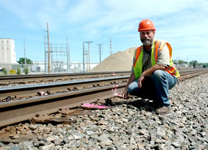
Tom Harper, survey crew chief, checks rail alignment along the Burlington Northern Santa Fe tracks that run parallel to Hwy 10 in Detroit Lakes. Photo by Craig Wilkins |
By Craig Wilkins
The Burlington Northern Santa Fe Railroad’s tracks parallel Hwy 10 for much of its length, especially where it runs through Detroit Lakes. There, the highway and the rails are only about 50 feet apart.
When District 4 staff began planning a new Hwy 10 alignment in the city, railroad officials required precise monitoring to detect the slightest movement of the rail bed during reconstruction.
To meet that requirement, District 4 and the railroad agreed to use a survey total station to send optic beams to a series of 64 prisms mounted on railroad ties. The station triangulates reflections from the prisms to determine any lateral or vertical movements.
If the system detects movement, it automatically notifies the railroad and the project’s survey crew by e-mail and a cell phone text message.
Tom Harper, survey crew chief, said the Leica-made system is widely used in Europe to detect movement in dams and in the United States to monitor mining operations. But this is the first time, he said, the system has been used for a highway project.
The district’s application of the high-tech system also reflects some home-grown ingenuity.
One total station unit rests on a salvaged metal platform. The trunk of a recently felled cottonwood tree supports the platform and stairs.
Harper and his crew fashioned rubber mounts for the set of 64 prisms from an old tire. The mounts cushion them from the pounding caused by a dozen or more heavy freight trains that rumble through the project area every day and from nearby pile-driving operations.

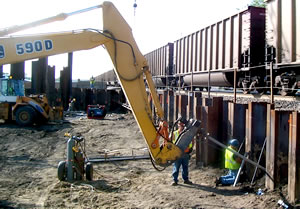
A construction crew works on the Roosevelt Avenue underpass as freight train passes by. The underpass and a new bridge will eliminate the at-grade rail crossing. Photo by Tim Swanberg |
The pile-driving is needed to build an underpass and a railroad bridge over Roosevelt Avenue, one of the city’s busiest streets, which will eliminate an at-grade crossing and the street’s intersection with Hwy 10.
The project, known as Connect Detroit Lakes, will also eliminate two at-grade crossings, straighten an S-curve on Hwy 10 and reduce the number of access points from 70 to 7.
The improvements will improve safety and mobility in the busy Hwy 10 corridor, said Shiloh Wahl, project engineer.
One part of the project, a rebuilt intersection for Hwy 34 and Hwy 59 in the city, was completed in July, a month early, Wahl said.
“To accommodate a five-lane bridge over the BNSF and Canadian Pacific rails, the Hwy 34 and Hwy 59 intersection in the city was rebuilt and widened. Construction was completed a month early," Wahl said.
“Grading for the BNSF tracks will be completed this fall. The BNSF will start building its tracks next spring and start running trains on the new alignment by July 2007. Once the BNSF has switched onto the new alignment, we’ll remove the old tracks and start building the new Hwy 10 alignment,” he said.
The $37-million project is a joint effort by Mn/DOT, the city of Detroit Lakes and the BNSF.
Harper said railroad and project staff worked intensely this spring to get the system operating reliably.
“We had some problems and a steep learning curve with the system at first,” Harper said, “but now the system is working as planned and we’re using it with little difficulty.”
Harper said the system has alerted him and the BNSF several times when movements have occurred.
The railroad, he said, has sent crews that check track alignments to prevent derailments or other problems.
“The system tells us first if there is a problem,” Harper said. “If a train discovers it first, it may be too late.”
|


