 |
|
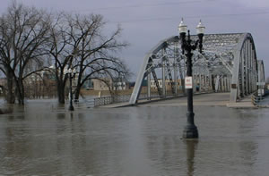
Rising floodwaters from the Red River of the North covered approaches to the Sorlie Bridge in East Grand Forks, one of many bridges closed between Minnesota and North Dakota during flood conditions. (The bridge that carries Hwy 2 between East Grand Forks and Grand Forks,
N.D. remains open.) Photo by Terry Sorenson
|
Sounding more than a bit weary, Terry Sorenson reported on April 11 that the last two sections of highway in his sub-area had just reopened to traffic.
Sorenson serves as supervisor for the Bemidji District’s southwest sub-area, an area hit hard by flooding from the Red River of the North and other streams and rivers.
He said that two sections of Hwy 75 that had been closed for several days near Climax and Shelly are now open although some are still covered by a few inches of water.
That’s good news in the region where many roads and bridges remain closed since flooding began in late March.
The floods moved steadily northward with the river’s flow, covering roads, washing out shoulders, and closing bridges as they advanced.
Mn/DOT crews worked with those from cities and counties, National Guard troops and hundreds of volunteers in response to the flooding.
Waters well above flood stage brought dark memories of the devastating 1997 floods, but dikes, floodwalls and other measures helped reduce effects from flooding.
 |
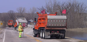
District 4 maintenance and sign crew members rebuild a section of Hwy 108 near Pelican Rapids damaged by pooled water caused by rain and snow melt. They hauled in rock and aggregate to raise a 1,500-foot section of the road five feet above the water level. Photo by Bill Hanson |
At Breckenridge, for example, a channel dug by the Corps of Engineers diverted the flow of the Otter Tail River east of town to avoid its meeting the waters of the Red in the city. The diversion worked, preventing a replay of the city’s devastation in 1997, which damaged District 4’s truck station as well as several employees’ homes.
This year, flooding in the city was minimal.
When floodwaters began to recede in the western part of the district, road crews started the task of repairing damaged shoulders, opening once-flooded roads to traffic and, in some cases, rebuilding damaged roads.
When high waters peaked, crews worked around the clock to erect barricades, sign detours and flag motorists through water-covered highways, said Dennis Redig, district maintenance superintendent.
Redig said crews also rebuilt damaged sections of Hwy 108 near Pelican Rapids and Hwy 34 near Dunvilla caused by snow melt and rainwater. The affected areas lack drainage outlets, he said, and pooled water washed out part of the roadway.
Maintenance and sign crew members hauled in rock and gravel to rebuild 1,500 feet of the roadway to raise it about five feet above the water.
He added that water covered many roads in the region, requiring workers to direct traffic through those areas around the clock for several days.
All roads in District 4 are now open, Redig said.
Lee Berget, district engineer at Detroit Lakes , estimates costs to repair damage from the floods will range from $400,000 to $500,000.
 |
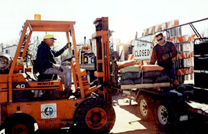
Charlie Hoff (in the loader) and Dave Larson, both transportation generalists at Crookston, load sandbags used to secure temporary detour and warning signs on flooded highways. Photo by Linda Swenson |
As the flooding moved north, crews from District 2 bore its brunt. Flood waters from the Red River, the Wild Rice River and other streams forced widespread road and bridge closings. Overland flooding isolated some cities such as Oslo and Halstad when roads such as Hwy 1, Hwy 200 and Hwy 220 were closed.
Sections of other highways such as Hwy 75, a major north-south route, were closed; others were passable but often covered by water.
Sorenson said road crews worked constantly for nearly two weeks dealing with the flood and its aftermath. Although there is obvious damage to pavements and shoulders, he said that the full extent of damage won’t be known until early summer.
Parts of highways in the district’s northwestern corner remain closed as of April 12. They include Hwys 1, 11, 171, 175, 220 and 317. Hwy 75 is closed between Hwy 171 and the Canadian border.
District officials noted that this spring’s floods were far less damaging than those in 1997. They said new dikes, flood walls and other measures prevented major flooding in cities such as Breckenridge, Moorhead and East Grand Forks.
While grateful for less severe flooding than in 1997, which severely damaged his home near Ada, Sorenson said this year’s floods “become sickening after a while, because the picture is so familiar.”
He said one constant among the floods of any year is the commitment of the people in his sub-area and the districts to bear up under constant pressure and exhaustion from dealing with the situation day after day.
“Sometimes we called people out two or three times during the day and we worked nights and weekends for nearly two weeks,” he said. “These events show the quality and dedication of our staff,” he said. “They always come through for us.”
By Craig Wilkins
|


